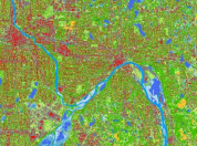
"Minnesota Geospatial Commons" Logo
  • Categories
  • Organizations
  • Resources
  • News
  • Help
  • About
  1. Home
  2. land use
  • Help Home
  • About the Geospatial Commons
  • What is a resource?
  • Search
  • Accessing & Using Resources
  • Becoming a Publisher
  • Publishing Resources on the Commons
  • Maintaining Resources
  • Library
  • Keep in Touch

New Land Cover Data and Twin Cities 2016 Imagery Added

A sample of land cover data from the Twin Cities metro

In honor of Geography Awareness Week, we'd like to announce the availability of several long-awaited datasets.

Land Cover and Impervious Surface Data

Tags: 
land use
land cover
imagery
air photo
  • Read more about New Land Cover Data and Twin Cities 2016 Imagery Added

Resources

  • What is a resource?
  • Accessing & Using Resources
  • Maintaining Resources
  • Data access API

Publishing

  • About the Commons
  • Becoming a Publisher
  • Expectations for Publishers
  • How do I publish resources?

Connect with us

  • Email us
  • Subscribe for e-mail updates